


Scientists and engineers have teamed up across the Atlantic to "redraw" the flood map of the US.
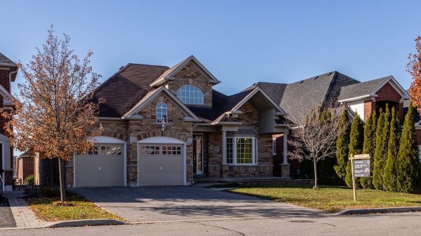
Their work reveals 40 million Americans are at risk of having their homes flooded – more than three times as many people as federal flood maps show.
The UK-US team say they have filled in "vast amounts of missing information" in the way flood risk is currently measured in the country.
They presented the work at the 2017 American Geophysical Union meeting.
This mapping project includes areas across the US that are on river floodplains and those at risk of flash floods associated with heavy rainfall.
It focuses on rivers and does not include areas at risk of coastal flooding.
Speaking to BBC News ahead of this international gathering of Earth and planetary scientists, one of the researchers, Oliver Wing PhD from University of Bristol in the UK, said the new maps were based on "cutting edge science", simulating every river catchment area.
The biggest issue, Mr Wing explained, is the how incomplete the network of river gauges is in the US. So he and his colleagues created a model based on decades of analysis of the way in which river systems behave.
This model "fills in those data gaps," he told BBC News, meaning the probability of flooding can be worked out in every river catchment area.
100-year flood
Combining those probabilities with population and land-use data, Mr Wing said, revealed that "40 million people and $5.5 trillion worth of assets" are within an area that has a 1% chance of flooding each year.
When you combine population data with government flood maps, which are created by the US Federal Emergency Management Agency (FEMA), "they only have 13 million people on that floodplain", said Mr Wing.
This area with 1% chance of flooding every year – also called the 100-year floodplain – is nationally recognised as the area of high flooding risk. FEMA charts this area on its official flood hazard map, which is used to inform a national flood insurance programme.
Flooding insurance is mandatory for the homeowners who have mortgages from federally regulated lenders. And for people whose homes were built before this law was passed, there is government support for their insurance policies.
But FEMA "simply hasn't covered the whole of the USA" in its mapping, Mr Wing told BBC News.
"Even in areas they claim to have studied, a lot of the smaller river reach has just been ignored."
FEMA said it had not carried out a full study of the number of people living in what it called Special Flood Hazard Areas, so it could not confirm the figures the team quoted.
But Roy Wright, director of the National Flood Insurance Programme, said that the organisation wanted "the best answers as the science advanced".
"We haven't seen the details of this study," Mr Wright told BBC News. "But we welcome what these scientists have done and, if it improves our maps, we'll look at it."
Modelling the strangest floods
- Hydrologists in a Princeton-Bristol University Partnership have also been examining and modelling some of the strangest floods to have happened in the UK and US.
- So-called "strange floods" are floods that are much larger than or that occur at unexpected times of year compared with more regular flooding in an area.
- These researchers developed what they termed a "strangeness index" for flooding. That is worked out by dividing the volume of water recorded in the largest flood, by the volume from a more typical flooding event. "The higher that value on the strangeness index, the more likely the flood is to happen at an unexpected time of year," explained Alexander Cox from Princeton University.
- Prof Paul Bates from the University of Bristol says their unexpectedness makes them difficult to prepare for, meaning they often cause large amounts of damage.
- Two of the strangest floods to have happened in the UK were on the River Darent at Hawley in Kent in September, 1968. "This was 10 times larger than the 10-year flood here," according to Prof Bates.
- More recently, a flood of the River Dearne at Barnsley Weir in South Yorkshire in 2007 was nine times larger than the 10-year flood in that area.
- According to the scientists, seven out of the top 10 strangest floods happened in only two years – 1968 and 2007.
- Alexander Co, lead researcher on the UK strange floods project, said understanding the strangest floods could add a whole new dimension to calculating flood risk.
Mr Wing added that the 100-year flood had the potential to cause $1.16tn worth of damage.
"That is if the 100-year flood happened everywhere at the same time, which is not going to happen in one period," he said. "But this gives you a rough idea of what has been put in harm's way.
Media playback is unsupported on your device
[contf] [contfnew] 
BBC
[contfnewc] [contfnewc]
The post US flood risk 'severely underestimated' appeared first on News Wire Now.


