


The weird thing about volcanic activity in the Western United States is that it’s actually quite difficult to explain. The Cascade volcanoes of the Pacific Northwest are one thing—standard tectonic plate boundary volcanoes like the rest of the Pacific Ring of Fire—but they are far from alone.
There is Yellowstone, of course, which has a history of frighteningly massive eruptions stretching across Idaho and into Wyoming. And neighboring the Cascades, a fair share of Washington and Oregon are blanketed by tremendous lava flows that erupted around 15 million years ago, while southeastern Oregon is home to Newberry Caldera and a line of related volcanoes. Nevada, meanwhile, is dotted by a string of smaller eruptions. (And we’re leaving out the Sierra Nevada Mountains and the Southwest entirely.)
There’s a lot of talk about a plume of hot mantle rock rising up beneath Yellowstone, which is what explains volcanic chains like the Hawaiian Islands. (The mantle plume stays in one place while the tectonic plate slides overhead.) But there is actually real disagreement about Yellowstone. Ultimately, this is because the last 50 million years in this region have been geologically wild, from the building of the Rocky Mountains to the stretching out of Nevada like an inhaling accordion and the creation of the San Andreas Fault. It’s… complicated.
A new study from a University of Illinois team led by Quan Zhou takes another whack at explaining things. The researchers basically create a computer simulation of the action beneath the surface by working backward. Given the CT-scan-like images we have of the tectonic plates and the mantle below them today and the records of tectonic plate motion over the last 20 million years, the model recreates the steps that would result in the correct present-day state.
The results suggest that a rising chimney of deep mantle rock has little to do with this story. Instead, it relates to the movement of tectonic plates at the top and some shallow areas of hot mantle that were taken for a ride.
Today, an oceanic plate is being subducted beneath the Pacific Northwest, but 30 million years ago that subduction zone extended all the way down the West Coast. When subduction in Southern California nibbled the oceanic plate all the way back to its source at a seafloor spreading boundary (where new oceanic crust slides apart like dual conveyor belts), there was nothing left to subduct, and the San Andreas Fault became the new king of the coast.
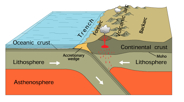
Underneath North America, that disappeared section of oceanic plate was still angling down into the mantle. Mantle is solid rock (not liquid magma) but it’s hot enough to very slowly flow like putty. And with this doomed plate sinking downward to the east, mantle rock from beneath the Pacific Ocean was pulled in behind it. It’s a bit like dragging a spoon through a jar of honey and watching honey get dragged along in its wake.
The mantle rock from beneath the Pacific happened to include some anomalously hot regions—probably related to some earlier shenanigans below the start of the conveyor belt. And so as the sunken plate drifted away, hot mantle rock settled in below western North America.
Now, the subducting oceanic plate going beneath the Pacific Northwest was still there, but around 17 million years ago a hole in that plate opened up underneath eastern Oregon. And in the model, this allows the hot mantle rock a pathway up to touch the continent. This is when the Columbia River Flood Basalt eruptions paved Oregon and Washington.
And then it gets weird
So far, so good, but the really strange thing about the eruptions that followed is that they trended in three different directions. Yellowstone eruptions stretched to the northeast over time, while the smaller Newberry eruptions marched westward. And the scattered eruptions in Nevada traced a southeasterly line, instead.
Here is what happens in the researchers’ model: the hot mantle rock essentially continues its eastward motion but runs into the thick continental crust of the Colorado Plateau and splits to the north and south.
To explain the westward movement of the Newberry eruptions in Oregon, we have to return to spoons and honey. If you start the spoon at the edge of the jar and move it toward the center, you won’t create a “hole” in the honey—honey will get sucked around the spoon to fill in the void. Similarly, the motion of a subducting plate sliding downward from the surface causes some shallow mantle rock to get sucked back into the narrow wedge where the oceanic and continental plates meet.
In this case, that included some of the invading hot mantle rock, which got sucked westward to fuel those Newberry eruptions.

Basically, the model shows hot rock from beneath the Pacific getting pulled under North America and being split in three directions. That would mean that three puzzlingly divergent areas of volcanic eruptions are actually from the same source. The researchers can’t rule out some contribution from a deep mantle plume, but their model doesn’t really need that to explain things.
Instead, the oceanic plate that California ate goes down—Terminator style (spoiler)—and lava eventually bubbles up onto a broad swath of the American West.
Nature Geoscience, 2017. DOI: 10.1038/s41561-017-0035-y (About DOIs).
[contf] [contfnew] 
Ars Technica
[contfnewc] [contfnewc]
The post Hunting for the reason why the Western US has so darn many odd volcanoes appeared first on News Wire Now.


